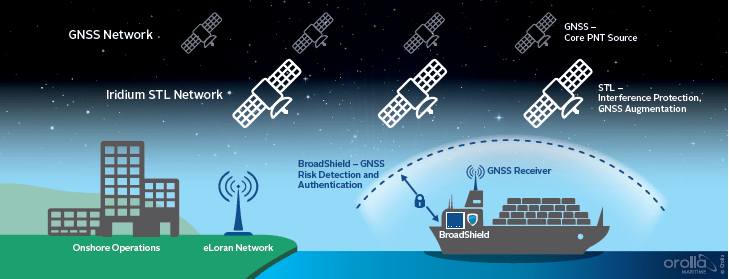
Recently, Maritime Executive published “Detecting and Defeating GPS Jamming Positioning” detailing the importance of maritime navigation and its dependency on Global Navigation Satellite System (GNSS) and position, navigation and timing (PNT) based on satellite input which is vital to many critical systems on board vessels. Also discussed is the growing awareness of the vulnerabilities of GNSS and potential solutions which are a combination of several alternative methods to augment GNSS and provide the resilience necessary for all critical operations. Satelles’ STL was mentioned in the article as follows:
“Alternative navigation signals such as Satellite Time and Location (STL), offer an encrypted signal, 1000 times stronger than GNSS that resists jamming and spoofing. STL is available worldwide, operating on the Iridium satellites. Though not as accurate as GNSS, it provides 30-50 meter accuracy which can serve as a check to the GNSS indicated position or time. When combined with an Inertial Navigation System (INS), it can provide valuable range and Doppler updates to the inertial measurements, reducing drift and maintaining a proper navigation solution, even during extended periods of GNSS denial.
Satellite Time and Location or STL offers an additional signal authentication tool through geo-location. STL’s encrypted signal means the vessel has an irrefutable PNT source, which in turn can authenticate communication or network access, as you can trust the vessel was in a certain location at a certain time and that communications to and from the vessel are genuine. This offers huge scope in cyber security, protection network access and the big data solutions that are rapidly changing the capabilities of the maritime industry. PNT is the foundation of trusted maritime navigation and with the latest technological advancements adding resilience, safer shipping can extend trust to cyber security and secure communication too.”